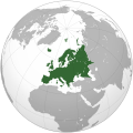
Dadai:Europe (orthographic projection).svg

Uaschbringlischi Dadai (SVG-Datei, Grundgreß 541 × 541 Pixels, Dadaigreß: 239 KB)
Die Dadai isch vun Wikimedia Commons unn konn a wuonaschda bnuzd werre. Ä Bschraiwung finschd Dadaibschraiwungssaid unne.
Iwwabligg
| BschraiwungEurope (orthographic projection).svg |
العربية: الخريطة الهجائية لأوروبا English: Europe
Français : Europe ქართული: ევროპა |
||||
| Dadum | |||||
| Gwell |
Aischenes Weag
|
||||
| Schraiwa | Ssolbergj | ||||
| Andere Versionen |
Abgeleitete Werke dieser Datei: Europe orthographic Caucasus Urals boundary.svg العربية: الرجاء، قراءة الميثاق.
বাংলা: দয়া করে, রীতিনীতিটি পড়ুন।
Deutsch: Bitte lies die Konventionen.
English: Please, read the conventions.
Español: Por favor, lea las convenciones.
Filipino: Paki-basa ang mga kumbensyon.
Français : S'il vous plaît, lisez les conventions.
हिन्दी: कृपया सभागमों को पढ़ लें.
Bahasa Indonesia: Silakan, baca konvensi.
Italiano: Si prega di leggere le convenzioni.
日本語: 規約をご確認ください。
ქართული: გთხოვთ, გაეცნოთ კონვენციებს.
Македонски: Ве молиме, прочитајте ги општоприфатените правила.
Português: Por favor, leia as convenções.
Русский: Пожалуйста, прочитайте соглашения.
Tagalog: Paki-basa ang mga kumbensyon.
Українська: Будь ласка, прочитайте конвенції.
Tiếng Việt: Hãy đọc công văn trước khi đăng.
|
||||
| SVG‑Erstellung InfoField |
Bwillischung
| Public domainPublic domainfalsefalse |
| This map is ineligible for copyright and therefore in the public domain, because it consists entirely of information that is common property and contains no original authorship. For more information, see Commons:Threshold of originality § Maps.
English | Español | Galego | Română | slovenščina | العربية | 中文 | +/− |
| Bildnotizen InfoField | Diese Datei ist annotiert: Betrachte diese auf Commons. |
Poland
Spain
Portugal
Africa
Asia
Norway
France
Italy
America
Moldova
United Kingdom
Russia
Ireland
Greece
Finland
Germany
Denmark
Corsica
Switzerland
Bulgaria
Iceland
Sicilia
Cyprus
Malta
Estonia
Svalbard
Greenland
Sardinia
Albania
Austria
Balearic Islands
Crete
Kurzbeschreibungen
Urheber Deutsch
Einige Werte ohne einen Wikidata-Eintrag
Urheberrechtsstatus Deutsch
urheberrechtlich geschützt Deutsch
Lizenz Deutsch
7. Janua 2009
MIME-Typ Deutsch
image/svg+xml
Dadaigschischd
Drigg uffn Zaidpungd zum oazaische, wies doad ausgseje hodd.
| Zaidpungd | Gleenes Bild | Maß | Middawaida | Oißarung | |
|---|---|---|---|---|---|
| agduell | 11:46, 31. Jan 2016 |  | 541 × 541 (239 KB) | Christina1969 | Reverted to version as of 19:08, 20 June 2009 (UTC) |
| 22:21, 8. Seb 2013 |  | 541 × 541 (235 KB) | Chipmunkdavis | Reverted to version as of 22:37, 8 July 2009 Restore to version which notes source | |
| 22:11, 12. Seb 2012 |  | 541 × 541 (82 KB) | Palosirkka | Scrubbed with http://codedread.com/scour/ | |
| 20:44, 4. Abr 2011 |  | 541 × 541 (235 KB) | Green, White and Gold | Reverted to version as of 22:37, 8 July 2009 | |
| 06:49, 3. Abr 2011 |  | 541 × 541 (239 KB) | ComtesseDeMingrelie | correcting Phasis riverbank | |
| 06:49, 3. Abr 2011 |  | 541 × 541 (235 KB) | ComtesseDeMingrelie | more common | |
| 06:44, 3. Abr 2011 |  | 541 × 541 (235 KB) | ComtesseDeMingrelie | most common definition | |
| 00:37, 9. Jul 2009 |  | 541 × 541 (235 KB) | Bosonic dressing | rv: yes - per Natl Geographic Atlas of the World, which trumps what might be an original concoction | |
| 15:50, 5. Jul 2009 |  | 541 × 541 (235 KB) | Ssolbergj | I based the border on http://en.wikipedia.org/wiki/File:Map_of_Europe_(political).png. Do you have a more reliable source? | |
| 21:08, 20. Jun 2009 |  | 541 × 541 (239 KB) | Bosonic dressing | Europe: orthographic projection - minor tweak of continental border in Caucasus |
Dadaivawendung
Die Said vawaisd uff die Dadai:
Globali Dadaivawendung
Die oannare Wikis bnudzn die Dadai:
- Vawendung uff ace.wikipedia.org
- Itali
- Peurancih
- Siprus
- Turuki
- Vatikan
- Iërupa
- Jeureuman
- Rumania
- Hongaria
- Polandia
- Moldova
- Austria
- Bèlgia
- Liechtenstein
- Luksèmburg
- Monakô
- Blanda
- Swiss
- Bèlarusia
- Bulgaria
- Ukraina
- Slowakia
- Rusia
- Denmark
- Swèdia
- Irlandia
- Islandia
- Latvia
- Lithuania
- Finlandia
- Èstonia
- Albania
- Andorra
- Bosnia Hèrzègovina
- Kroasia
- Malta
- Yunani
- Seupanyo
- Sèrbia
- San Marino
- Portugéh
- Monténègrô
- Slovenia
- Norwègia
- Cèkia
- Pola:Iërupa
- Kosovô
- Vawendung uff af.wikipedia.org
Gugg fa waidare Vawendunge vunde Dadai.
Medadaade
Die Dadai hodd waidare Oagawe, waschoinlisch vunde Digidalkomara odda vum Skänna, wumase midd gmachd hodd.
Wonn die Dadai vaännad worre isch, konns soi, daß zusedzlischi Oagawe nemme rischdisch sinn.
| Breite | 541.47876 |
|---|---|
| Höhe | 541.47876 |


