
Gaarbuerj
| Gaarbuerj | |
|---|---|
|
| |
 | |
.svg) | |
| Verwaltung | |
| Land |
|
| Region |
|
| Département | Moselle (57) |
| Arrondissement | Sarrebourg |
| Kanton | Phalsbourg |
| Kommunalverband | Pays de Phalsbourg |
| Maire | Christian Fries (2014-2020)[1] |
| Code Insee |
57244 |
| Boschtlaitzahl |
57820 |
| Aiwohner | |
| Aiwohner | 490 |
| Flech | 8,34 km2 |
| Bevelkerungsdicht | 59,95 Iiw./km2 |
| Lach | |
| Koordinate | 48° 42′ 40″ N, 7° 13′ 59″ E / 48.711111111111°N,7.2330555555556°EKoordinate: 48° 42′ 40″ N, 7° 13′ 59″ E / 48.711111111111°N,7.2330555555556°E |
| Hech | 383 m |
 Gaarbuerj Gaarbuerj (Frankraich) | |
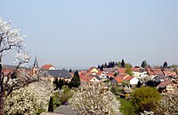
Gaarbuerj (lothringisch; frànzésch Garrebourg, daitsch Garburg) ìsch e frànzésche Gemään im Département Moselle in de Rechion Grand Est (bis 2015 Rechion Lothringe).
D Gemään gheat zum Kanton Phalsbourg im Arrondissement Sarrebourg.
Verwaltung
[Schaffe | Om Gwelltegschd schaffe]De Maire vun Gaarbuerj isch de Christian Fries. Gaarbuerj gheat zum Kommunalvaband Pays de Phalsbourg.
Bevelkerungsentwicklung
[Schaffe | Om Gwelltegschd schaffe]| Johr | 1968 | 1975 | 1982 | 1990 | 1999 | 2008 |
| Aiwohner | 479 | 536 | 518 | 518 | 496 | 510 |
Dialekt
[Schaffe | Om Gwelltegschd schaffe]De lothringisch Dialekt vun Gaarbuerj gheat zum Rhaifränkisch.
Bauwerg
[Schaffe | Om Gwelltegschd schaffe]- Kìrch Sànkt Coloman (1930)
-
Gaarbuerj -
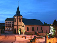
Kìrch Sànkt Coloman

Weblinks
[Schaffe | Om Gwelltegschd schaffe]Fußnote
[Schaffe | Om Gwelltegschd schaffe]- ↑ (franzesisch) Liste des maires au 25 avril 2014 (data.gouv.fr)
Arzviller | Berling | Bourscheid (Moselle) | Brouviller | Dabo | Danne-et-Quatre-Vents | Dannelbourg | Garrebourg | Guntzviller | Hangviller | Haselbourg | Henridorff | Hérange | Hultehouse | Lixheim | Lutzelbourg | Metting | Mittelbronn | Phalsbourg | Saint-Jean-Kourtzerode | Saint-Louis (Moselle) | Vescheim | Vilsberg | Waltembourg | Wintersbourg | Zilling